Deutschman Lab Projects
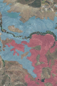
In September 2013, SANDAG received a final vegetation classification map for Western San Diego County. This mapping utilized a classification system generated for San Diego County that builds off the National Vegetation Classification System and the California Manual of Vegetation. The vegetation mapping consists of 21,036 polygons characterized by the hierarchical structure of "Group", "Alliance", and "Association." The mapping extent called for mapping with the proposed preserves of the NCCP and a buffer of lands surrounding the proposed preserve as worked out directly with the consultant. The effort involved office-based mapping using heads-up digitizing of 2012 imagery (Google and Bing datasets).
The accuracy of this vegetation map will be assessed by statistical analysis of the vegetation mapping project, field surveys to evaluate the spatial correspondence (or registration) and classification (or attribution/ thematic accuracy) of polygons, and review the sources of error. Violations of the minimum mapping unit will be examined, as will the distribution of polygon area data, which will provide an estimate of how well the minimum mapping unit was applied, and potentially serve as an indication of overall mapping effort spatially and across vegetation types. All statistical summaries will be conducted at the group, alliance, and association levels. To assess the spatial correspondence (or registration) and classification (or attribution/ thematic accuracy) of polygons, field data will be collected using a sample of polygons. The sampling plan will be based on the frequency and size of the groups, alliances, and associations. In addition, the sample will be balanced across the entire map area. A field assessor will navigate to the randomly selected polygon and classify the polygon using the new Western San Diego Vegetation classification key, record their findings, and provide a subjective confidence rating of their results. A confusion matrix will be constructed to summarize these data.
Research Tasks
1. Statistical Analysis of Vegetation Mapping Products
2. Field Based Accuracy Assessment
3. Comprehensive Review of Sources of Error and Recommendations
Lead Biologist: Douglas Deutschman, Spring Strahm
Accuracy Assessment of the Vegetation Map of Western San Diego County